Dry Reservoir parking lot. Ride time 9am.
Everyone welcome. Bring plenty of water its going to be hot hot!!
There is a nice place to jump in the stream near the end of the ride.
2014 Memberships Here!

Club Rides & Calendar
- Sundays 9:00 am - Various Locations - posted Weekly
- Thursdays 5:00 pm - Old Reservoir Lot at Milesburn Road and Rt. 233
Popular Ride Locations
View MBM Ride Parking in a larger map
Cool Places and People
Area Organizations
Trails
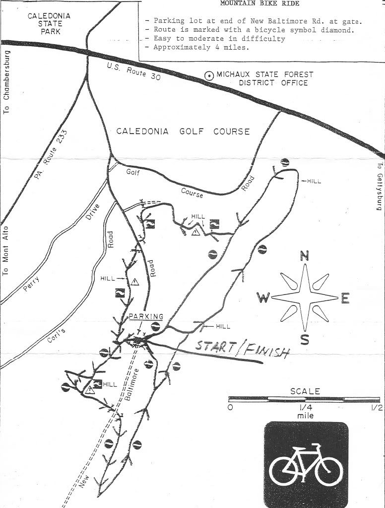
Click to enlarge & print

Blog Archive
-
▼
2012
(248)
-
▼
June
(19)
- Need post privileges?
- Sunday Ride
- Feminine Fire Road Fitness
- Some Pics, Yo!
- Post ride report from 6-24-12
- Sunday Ride
- New Member
- non-honey stingers
- Wednesday 6-20 Evening Trail Work
- Tuesday Ride
- Sunday 6/17 Ride - Pine Grove Furnace
- Trials bike For Sale
- Wednesday Ride
- Thursday ride - Long Pine Reservoir 5p
- Tuesday Ride Big Flat 5p
- Post group ride report 6/10/12
- Sunday Ride - Old Forge
- Crash visits Rockburn Skills Park and learns to pump
- Tuesday night ride???
-
▼
June
(19)
15 comments:
Where is the parking lot located. Directions from chambersburg would be fantastic. Im new to pa, and this will be my first mountain bike ride here.
Thanks
John
Does anyone have any good trail maps for michaux. I got the map from the forestry dept. but this does not show detailed trail info. Something I can download and print would be great. Thanks in advance!
Sunday's ride location can be found in the side bar on the right side of the title page.
To aquire a detailed trail map of Michaux, ride with MBM and remember what you ride.
John, It's listed as Old Reservoir on the locations and parking areas map on the side bar.
JPC there is a parking location map on the right side of the blog. Michaux trails are not mapped, maps that exist are not useful for navigating on your own especially when you are unfamiliar with the area.
Make sure you are prepared to do some climbing. The nice thing about this Sunday is the bailouts will be downhill to the parking area.
Howard is mistaken. We have several members who ride all the time and have no idea where they are!! Or where they are going for that matter.
True dat Slow.
The forestry office does offer one map that is helpful for navigating a few good trails in the Long Pine Reservoir area. It's called the Flat Rock Shared Use Trail System.
If you would like to obtain a great topographical map of Michaux, check out the PATC(Patomic Appalachian Trail Club) website. There you can purchase awesome, waterproof topo maps that cover the entire forest. These maps include the AT and some other hiking trails along with all the fire roads and a bunch of gated double track. You won't find any of the sweet mtb singletrack on the maps but they can be very helpful to you. Of course, that's only if you like to roll old school and low tech like me.
You can also purchase the PATC maps at the Pine Grove Furnace State Park office--they are really valuable for learning the lay of the land. I'm with Howard on this one--little tiny GPS screens don't let you see the big picture!
"We have several members who ride all the time and have no idea where they are!! Or where they are going for that matter" .....gee....sounds like TORC.
brett and howard....i'd like to see one of those maps sometime to see if it's something i'd wanna buy.
I appreciate it, will see you on Sunday!
I think it would be helpful if the ride leaders tell us what trails we're on and the trails that we intersect (since we usually wait at those intersections anyways). This will help those of us that are trying to add to our "Michaux mental map". The ride leaders do tell us sometimes and I've asked at times, too. I would just like to see it happen more often so that all of us can learn the trails.
You are right H.
I totally agree.
That would be very helpful.
I've been saying that for years!
The ride leaders are lost most of the Time. Most of the time the trails have the same name with everyone, but there are a few some people call a different name. When I'm along I'll be glad to share my wealth of knowledge. If I can remember !
Another good ride today!
Post a Comment